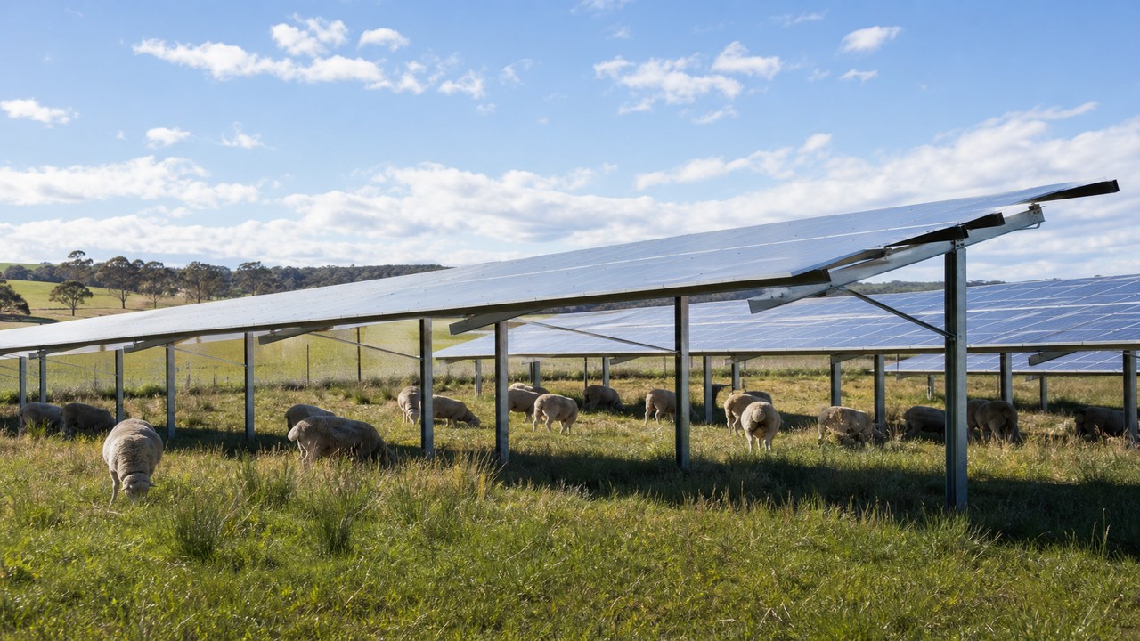
Dual land use pilot pairing sheep grazing with elevated arrays in flood-aware country—informing lease structures and operations manuals for agricultural continuity.
Challenge
Historical inundation and grazing patterns demanded panel height and drainage design validated by agronomists—not generic ground-mount assumptions.
Solution
Elevated structures, monitored grazing protocols and drainage models tested against inundation records before full-scale replication.
| Capacity | Pilot scale embedded generation |
|---|---|
| Land use | Sheep grazing + solar |
| Location | Murray region, Victoria |
| Role | Development & EPC pilot |
| Status | Operational pilot |
Challenge
Murray Plains country floods intermittently; grazing income must continue for host viability. Standard low-mount layouts were incompatible with flock movement and fodder management. Historical inundation maps showed partial array zones that could not be treated as ordinary buildable land.
Our approach
We co-designed row spacing and panel height with agronomists, installed drainage that respects natural flow paths, and documented biosecurity and fencing protocols. Construction occurred outside lambing windows agreed with the host.
Monitoring includes pasture cover, soil compaction and generation—reported quarterly to inform scale-up decisions.
Outcomes
Pilot operational with monitored pasture performance and generation data shared with hosts and investors considering larger agrivoltaic programmes. Lease templates for dual land use now reference this pilot’s operations manual.
Technical resolution detail
Panel height and row spacing were validated with agronomists for Merino and crossbred grazing patterns used on the host property. Drainage design retained overland flow paths identified in hydrological studies rather than blocking natural flood routes.
Fencing, biosecurity and vehicle wash-down protocols were integrated into construction logistics so neighbouring pastoral operations were not placed at disease risk during mobilisation.
Measured results
- Pilot energised with dual land-use lease and operations manual adopted by host
- Pasture cover and soil compaction monitored quarterly against control paddocks
- Generation data supports scale-up feasibility without overstating MW capacity
- Planning conditions closed with ecological monitoring obligations scheduled
Lessons for agrivoltaic scale-up
Sheep grazing metrics must lead go/no-go decisions for expansion—not only MW capacity. Host trust depends on visible pasture management during drought years when generation may peak but fodder stress is highest.
Community and planning continuity
Neighbour and council confidence on agricultural land depends on demonstrating that drainage, access roads and glare management were designed for the property—not imported from a generic utility template. We maintain a single planning register linking offset conditions to layout revisions so auditors can trace why row spacing changed between concept and construction.
Landowners evaluating expansion should treat agronomic monitoring as a gate equal to grid studies: if pasture condition diverges from baseline for two seasons, we pause scale-up conversations until grazing management is corrected, even when connection capacity becomes available.
Project FAQ
Why elevated structures?
Sheep movement and fodder management required height and row spacing validated by agronomists.
How was flood risk addressed?
Drainage retained natural flow paths from hydrological studies—not blocked for array layout convenience.
Is the pilot being scaled?
Monitoring pasture and generation quarterly informs scale-up decisions—not MW announcements alone.
Explore related work

Discuss your project
Share site or portfolio context for structured assessment.